Brisbane locals call it Straddie. It's the second-largest sand island in the world (after K'gari, just up the coast), it's drive-on-able with a vehicle ferry, and it gives Brisbane its closest taste of proper open-coast surf without flying anywhere. You can be on the beach for breakfast and back in the city for dinner.
- State
- Queensland
- State capital
- Brisbane (40 km west)
- Indigenous name
- Minjerribah
- Traditional Owners
- Quandamooka people
- Size
- 275 km², 38 km long
- Population
- ~2,400 permanent
- Best time to visit
- April to Nov (cooler, drier)
How to get there
From Brisbane, drive 50 minutes east to Cleveland. Two ferry operators run from there: Stradbroke Ferries and SeaLink Stradbroke Island. The vehicle barge takes 45-50 minutes; the passenger water taxi takes 25. Both run roughly hourly during the day, with reduced services after dark.
If you're going across without a car, the water taxi drops you at Dunwich, where Translink buses connect on to Point Lookout (the main beach town) and Amity Point. Buses are timed to ferry arrivals.
The island has a 4WD beach driving culture, but the main settlements are reached on sealed roads, a 2WD is fine if you're not heading down Main Beach itself. To drive on the beach you need a permit ($43.95 from Quandamooka Yoolooburrabee Aboriginal Corporation, who manage the protected areas).
Approximate costs
| Item | Cost (AUD) |
|---|---|
| Vehicle ferry return (car + driver) | $160 to $190 |
| Water taxi return (foot passenger) | $23 |
| Beach access permit (4WD, per vehicle) | $44 |
| Camping permit (per night, family) | $30 |
| Apartment / unit (per night) | $160 to $320 |
| Boutique stay (per night) | $320 to $580 |
| North Gorge Walk | Free |
| Whale-watching boat trip | $95 to $130 |
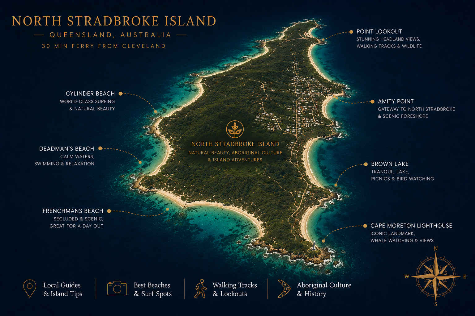
What to do
The North Gorge Walk
Twenty minutes return on a paved boardwalk circling a basalt headland at Point Lookout. From June to November you can see migrating humpback whales right under the cliffs, sometimes within 100 metres of shore. Year-round there are turtles, dolphins, manta rays and (in summer) reef sharks visible in the gorge below. Easily the best free activity on the island.
The beaches
Cylinder Beach at Point Lookout is the main swimming beach, sheltered, lifeguarded, family-friendly. Main Beach stretches 36 km down the eastern side and is the surf one, open ocean, big swells, and the access road for 4WD beach driving. Frenchman's Beach is small, wedged between rocks, and never crowded. Home Beach at Amity Point is calm and warm, sheltered by the bay.
The freshwater lakes
Like K'gari, the island has perched freshwater lakes with extraordinary clarity. Brown Lake (Bummiera) is tannin-stained from tea-tree leaves; the water is the colour of weak coffee but clean as glass. Blue Lake (Karboora) requires a 5 km return walk, and the water there is turquoise. Both are sacred sites to the Quandamooka, bathing is permitted but please respect signage.
Whale watching by boat
Operators run from Point Lookout from June to November. The waters off Straddie sit in a major migration corridor; sightings during the season are guaranteed.
Surf
Cylinder, Main and Frenchman's all break depending on swell and wind direction. Surfboard hire and lessons are available year-round at Point Lookout. The waves are best in autumn and winter.
When to visit
April to November is the sweet spot, comfortable temperatures, lower humidity, whale season, no stinger risk. The summer holidays (mid-December through January) are the busiest weeks of the year and accommodation prices double. Mid-week in autumn is ideal: empty beaches, warm water, all operators running. Easter is busy. The school holiday weeks of June-July fill up for whale watching.
What to bring
- Reef-safe sunscreen
- Hat, sunglasses
- Swimmers and rashie
- Walking shoes for the gorge boardwalk
- Light jacket for ferry deck (windy)
- Snorkel kit (optional)
- Esky for groceries, supermarket is small
- Cash optional (most places card-friendly)
- Tide chart if 4WD-ing the beach
- Binoculars for whales
A bit of history
Straddie is the country of the Quandamooka people, the Nughie of the north, the Nunukul of the south, and the Goenpul. Archaeological evidence places continuous occupation back at least 25,000 years. The Quandamooka name for the island is Minjerribah.
European contact began in 1803 when Matthew Flinders charted Moreton Bay. The island became part of the colonial mission system in the 19th century, and from 1949 was extensively sand-mined for mineral resources. Sand mining ended in 2019 after a long campaign, and the island's economy has since shifted firmly toward tourism, conservation and Quandamooka-led cultural enterprise. The 2011 Native Title determination recognised the Quandamooka people as the traditional owners. They now manage the national parks across the island in partnership with the Queensland government.
"Stradbroke" comes from Lord Stradbroke, a 19th-century British peer who never visited. The Quandamooka name is being used more widely on signage and in tourism material, you'll see both.
Where this is on the map
Off the southeast Queensland coast, just east of Brisbane.
Other islands you might pair with this
Straddie pairs naturally with K'gari (Fraser Island) further north, same sand-island geology, much wilder. Lord Howe is the next island south of Brisbane if you want to step up to a true Pacific outpost.