Kangaroo Island is bigger than you expect. 155 km long, with sealed highways, a working farming community, and enough distance between the good things that you can't reasonably do it in a day. Three nights is about right. Two if you're brisk.
- State
- South Australia
- State capital
- Adelaide (160 km north)
- Indigenous name
- Karta Pintingga
- Size
- 4,405 km² (3rd largest in Aus)
- Population
- ~4,800 permanent
- Best time to visit
- March to May, Sept to Nov
How to get there
From Adelaide you've got two options. The first is to drive 90 minutes south to Cape Jervis and take the SeaLink car ferry to Penneshaw, 45 minutes, runs roughly hourly in summer. The second is to fly from Adelaide to Kingscote with Rex Airlines, 30 minutes in the air.
If you want to actually see the island, take the ferry and bring your car. Public transport on KI is nonexistent. There are tours, but you're locked into their schedule and you'll miss anything they don't drive past.
Approximate costs
| Item | Cost (AUD) |
|---|---|
| Ferry passenger return (adult) | $110 |
| Ferry car return (standard) | $220 to $280 |
| Flight Adelaide-Kingscote return | $280 to $450 |
| Hire car on KI (per day) | $95 to $160 |
| Flinders Chase NP entry (per vehicle) | $13.50 |
| Seal Bay guided tour (adult) | $42 |
| Accommodation B&B (per night) | $180 to $350 |
| Lodge / boutique (per night) | $400 to $1,200 |

What to do
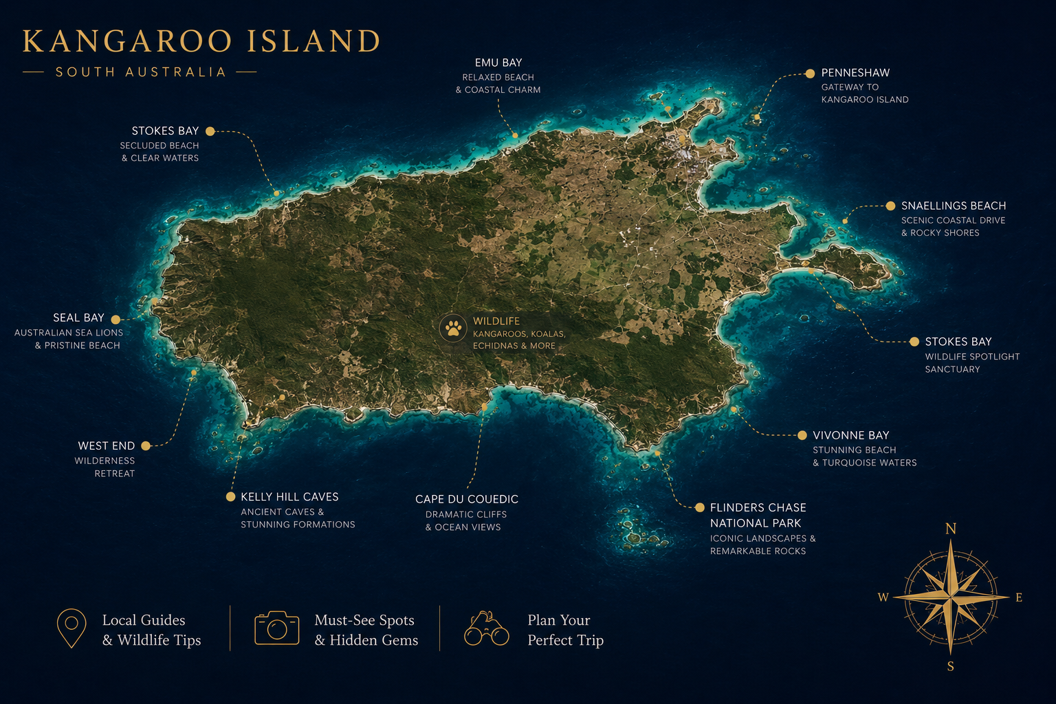
Treat the island as four chunks: Penneshaw and the east end (where the ferry lands), the central farmland and Kingscote, the south coast and Seal Bay, and Flinders Chase at the western end. You'll need a vehicle to move between them.
Flinders Chase National Park
The far west. Remarkable Rocks are exactly that, wind-sculpted granite boulders perched on a headland above the Southern Ocean. Best at sunrise or late afternoon. Admirals Arch is a 15-minute walk away and has a colony of long-nosed fur seals you can watch from the boardwalk. Both are signposted off South Coast Road.
Note: Flinders Chase was hit hard in the 2019-20 bushfires. Most of the park burnt. The visitor centre was rebuilt in 2023 and the bush is regenerating well, but you'll see the impact for years yet. The park is fully open.
Seal Bay
A colony of around 800 Australian sea lions. Access is by guided beach tour only, you walk down with a ranger and stand among them at a safe distance. Don't skip the briefing; this is the only place in the world where the public can do this.
Food and wine
The island has a serious food culture for its size. Try the eucalyptus honey from Clifford's Honey Farm (the bees are pure Ligurian, the only quarantined population of them in the world), KI marron from Two Wheeler Creek, and the gins coming out of Kangaroo Island Spirits in Cygnet River. The local oysters are excellent.
Beaches
Stokes Bay is the local trick, you walk through what looks like a dead-end of boulders and emerge on a hidden white-sand beach. Vivonne Bay is gorgeous and almost always empty. Emu Bay is good for swimming with kids.
When to visit
Autumn (March to May) is generally the best window: still warm, fewer crowds, southern right whales sometimes visible from the south coast in late autumn. Spring is similar but with wildflowers and lambs. Summer is hot and very busy; the south coast can be brutal in a heatwave. Winter is wet and cold but the seal pups are around and the food and wine producers are easier to book.
What to bring
- Layers, coast can be 10°C cooler than inland
- Decent walking shoes
- Sunscreen, hat, sunglasses
- Reef-safe swimmers
- A cooler if road-tripping (cheese, oysters, etc.)
- Esky / chiller bag for produce
- Insect repellent (mosquitoes at dusk)
- Cash for the few honesty boxes at farms
- A long charging cable, distances are real
- Binoculars for whale-watching season
A bit of history
For thousands of years the island was inhabited by Indigenous people, archaeological evidence suggests human occupation as far back as 16,000 years ago, when the island was still connected to the mainland. By the time European explorers arrived in the early 1800s, the island had been uninhabited for several centuries. It carries the Ngarrindjeri name Karta Pintingga, "Island of the Dead."
British navigator Matthew Flinders charted the island in 1802 and named it Kangaroo Island after his crew shot 31 of the local kangaroos to feed themselves, a fact the island has gently lived with ever since.
The island became a sealing and whaling base in the early 19th century, then a farming community. The 2019-20 bushfires destroyed roughly half the island's vegetation and significant private property. Recovery is ongoing; many of the small operators you'll visit have rebuilt from scratch.
Where this is on the map
13 km off the southern tip of the Fleurieu Peninsula, south of Adelaide.
Other islands you might pair with this
If KI has whetted your appetite for big-island, drive-yourself trips, try Bruny Island in Tasmania, same scale of food culture, even more dramatic coast. Phillip Island in Victoria is much smaller but a similar drive-on, drive-off proposition.