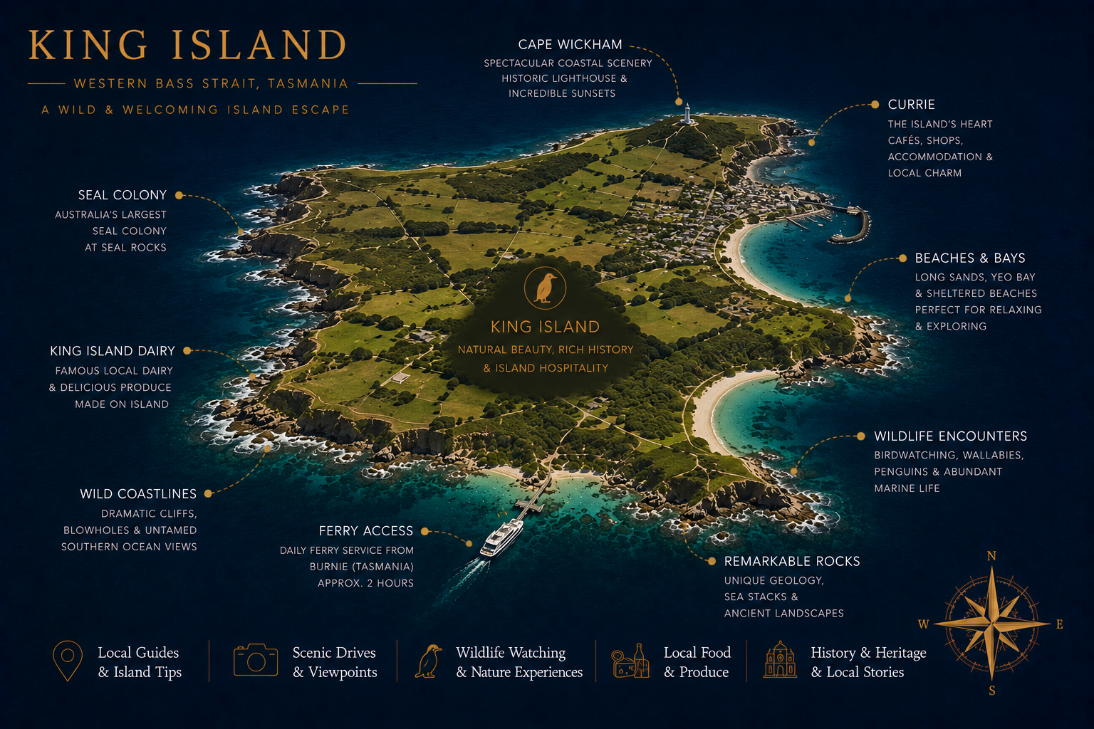
King Island sits in the middle of Bass Strait, halfway between Tasmania and the mainland. The pasture is so good that the local dairy has won every cheese competition that exists. The same fertile country produces beef that turns up by name on Melbourne menus. Two of Australia's top-ten golf courses are here, side by side. The coast is wild, dotted with lighthouses and the wrecks of dozens of ships that didn't make it through the Strait.
- State
- Tasmania
- State capital
- Hobart (320 km southeast)
- Indigenous name
- loontitetermairrelehoiner
- Size
- 1,098 km², 64 km long
- Population
- ~1,600 permanent
- Best time to visit
- Nov to April (warmer)
How to get there
Flights only. Sharp Airlines and King Island Airlines run direct services from Melbourne (Essendon and Tullamarine), about 50 minutes, and from Burnie in northwest Tasmania. There are no direct flights from Hobart; you'd have to connect through Burnie or Melbourne.
There is no passenger ferry. There used to be one, it stopped in 2013 and hasn't been re-established despite periodic campaigns.
You'll want a car on the island. Roads are sealed, distances are real, and tour buses are limited. Most accommodation packages include a hire car.
Approximate costs
| Item | Cost (AUD) |
|---|---|
| Return flight from Melbourne | $420 to $720 |
| Return flight from Burnie | $320 to $520 |
| Hire car (per day) | $70 to $110 |
| B&B / motel (per night) | $160 to $290 |
| Boutique accommodation (per night) | $320 to $580 |
| Cape Wickham Golf Links (green fee) | $220 |
| Ocean Dunes Golf (green fee) | $170 |
| King Island Dairy farm shop (cheese tasting) | $10 |
What to do
Eat the dairy and the beef
King Island Dairy at Loorana has a small visitor centre where you can taste their full range, the Roaring Forties Blue is internationally recognised, the Brie de Phoque is a personal favourite. Pick up at the farm gate. King Island Beef is sold direct from local butchers; the Wagyu cross from Bass Strait Beef is what makes Melbourne menus.
Cape Wickham Golf Links
Routinely ranked in the world's top 25 public golf courses since opening in 2015. Cliffs, dunes, surf, the kind of links course that gets photographed for calendars. Booking ahead is essential.
Ocean Dunes
The other major links course, on the west coast. Different in character, shorter, more dune-lined, slightly more forgiving. Combined with Cape Wickham, the two make a serious golf weekend on a small island.
Cape Wickham Lighthouse
Built in 1861, the tallest lighthouse in Australia at 48 metres. Open for tours. Set against cliffs that have claimed dozens of ships, the wreck of the Cataraqui in 1845 (the worst civilian maritime disaster in Australian history) happened nearby; over 400 souls were lost.
Currie and the small towns
Currie is the main town and where you'll fly into. Naracoopa on the east coast is smaller, with the longest jetty on the island and good walking. Grassy on the south coast is home to the Grassy Harbour and the famous Penguin Walk at dusk.
Storm watching
King Island sits in the path of the Roaring Forties. Big seas and dramatic skies are constant in winter and frequent in summer. The best storm-watching is from Calcup Hill Lookout or the cliffs at Disappointment Bay.
When to visit
November to April is the warmer window, with comfortable temperatures, longer daylight for golf and less rain. Winter is cold, wet and windy, but storm-watching, dramatic light and cheaper accommodation are real attractions if you don't need to be outside all the time. Summer is busiest for golf; book courses and accommodation 4+ weeks ahead.
What to bring
- Layers, Bass Strait weather changes constantly
- Waterproof / windproof jacket
- Walking shoes
- Golf clothes (collared shirts at Cape Wickham)
- Esky for taking cheese home
- Beanie and gloves Apr-Oct
- Camera with weather sealing
- Cash for some small operators
- Snacks for road trips
- Patience for the weather
A bit of history
The island is part of the traditional country of the Tyereelore people of the Palawa nation. The Tyereelore population on King Island was small at European contact and the community was effectively eradicated through the violent dispossession of the early 1800s. The traditional name loontitetermairrelehoiner is still used.
European contact began with sealers in 1798, the same year George Bass charted Bass Strait. The island was named after Philip Gidley King, governor of NSW. Sealing decimated the local fur seal population in less than a decade. Pastoral settlement followed in the 1880s, with the dairy industry establishing itself by the 1890s.
Bass Strait is one of the most dangerous stretches of water around Australia, well over 70 ships have been lost on the King Island coast alone. The most famous wreck, the Cataraqui in 1845, remains Australia's worst peacetime maritime disaster.
Where this is on the map
Western Bass Strait, halfway between Victoria and northwest Tasmania.
Other islands you might pair with this
Flinders Island at the eastern end of Bass Strait pairs naturally, the same wild Bass Strait character, different in scale. Bruny Island is the obvious food-and-coast Tasmanian sibling.